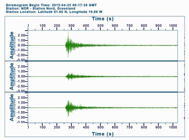
 The Gorkha Earthquake was clearly detected by seismographs at Station Nord in Greenland, 7,113 km (4,420 mi) from the earthquake epicenter.
A massive earthquake of magnitude 7.8 struck Nepal on April 25, 2015 at approximately 6:11 am (UTC) (2:11 am EST). The epicenter of the earthquake was located 77 km (48 mi) to the northwest of Kathmandu, the capital of Nepal. The hypocenter of the earthquake was at a depth of approximately 15 km (9.3 mi). The earthquake was of sufficient strength that seismograph stations around the world registered its impact. This earthquake in Nepal is now officially known as the Gorkha Earthquake. The Gorkha Earthquake released so much energy that the Earth’s crust in Nepal experienced a massive disturbance that resulted in a major shifting of the Earth’s surface.
Land Deformation in the Gorkha Earthquake
A ShakeMap plots the intensity of ground shaking produced by an earthquake.
- Click here to see a ShakeMap for the Gorkha Earthquake.
The shake intensity of two of the contour lines has been clearly labelled.
- Locate these two contour lines.
- What is the intensity for each of these two contour lines? The two contour lines have labelled intensities of VII and VIII respectively.
- What is the contour interval (i.e. the change in shake intensity between adjacent contour lines)? The contour interval for adjacent shake intensity lines is ½.
- What was the shake intensity at the epicenter? The shake intensity at the epicenter was between VIII and VIII ½.
- How does the legend describe the “Potential Shaking” for this shake intensity? The legend describes the “Potential Shaking” as somewhere between “Severe” and “Violent”.
- What “Potential Damage” is possible according to the legend for this shake intensity? The “Potential Damage” lies somewhere between “Moderate/Heavy” and “Heavy”.
- Click here to add in the location of Kathmandu.
- What was the shake intensity at Kathmandu? The shake intensity at Kathmandu was somewhere between VII ½ and VIII.
The ground-shaking from the Gorkha Earthquake resulted in some permanent deformation of the Earth’s surface.
- Click here to see a satellite view of these surface displacements.
This view, known as an interferogram, uses color fringes (i.e. contours) to show permanent surface displacements.
- How much surface motion is represented by each color cycle? Each color cycle represents a change of 11.9 centimeters (4.7 in) in the height of the Earth’s surface.
- What does the relative spacing of the color fringes indicate about the degree of land deformation? Close spacing of the color fringes indicates that a great deal of land deformation occurred within a very short distance. Areas that had wide spacing in the color fringes experienced land deformation that was less intense and that was spread over a much larger area.
- Was there a lot of land deformation near Kathmandu? Explain. Yes, there was a lot of land deformation near Kathmandu because the color spacing is fairly close at this location.
The interferogram gives scientists information about individual ground movements in specific areas. Summing up the individual movements in the color fringes allows scientists to see the overall permanent deformation in the area.
- Click here to see a view of the overall permanent deformation of the Earth’s surface caused by the Gorkha Earthquake.
- What displacement occurred in the Earth’s surface near Kathmandu? The Earth moved upwards approximately 1.5 m (5.0 ft) in the vicinity of Kathmandu.
- What was the maximum displacement in the mountains north of Kathmandu? The mountains north of Kathmandu moved downwards approximately 1.5 m (5.0 ft).
The Biggest Earthquake
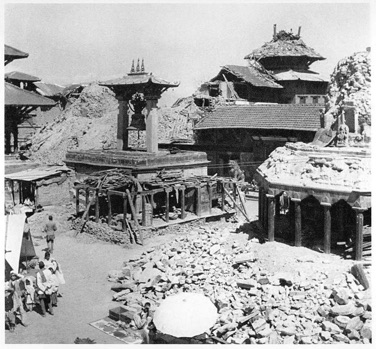 Kathmandu suffered extensive damage as a result of the 1934 earthquake.
Nepal’s biggest earthquake occurred on January 15, 1934. The epicenter for this 8.1 magnitude quake was located approximately 9.5 km (5.9 mi) south of Mt. Everest. This devastating earthquake resulted in over 10,500 deaths and caused widespread damage both in Nepal and India.