Geologic Historian
Objective: The purpose of this activity is to analyze layers of rock that have been exposed in several canyon areas in order to learn more about their geologic history. You will analyze the rocks for ages, common rock layers, and the depths of rock layers.
Materials Required: Everything that you need for this exercise is included in the on-screen components.
Time Required: approximately one hour
You are a geologist working for the Layered Earth Analytics Corporation (LEAC). Your company, LEAC, has recently been asked by the United States Geologic Survey (USGS) to analyze the layers of rock that have been exposed in several canyon areas in the Colorado Plateau. Your task is to examine the rock profile for certain areas, and then to analyze the rocks for ages, common rock layers, and the depths of rock layers. This information will help the USGS learn about the geologic history of this area. Your skills of observation, measurement, mathematics, and analysis (i.e., the exact skills that got you hired by LEAC in the first place) will be particularly useful in this exercise.
Part A: Data Locations
The USGS has asked you to examine the data from three different areas that each exhibit prominent rock exposures. These three areas are Flaming Gorge National Recreational Area (Wyoming), Arches National Park (Utah), and Glen Canyon National Recreation Area (Utah). Your first task will be to place your three data areas in their physical context.
- Click here to view the location of the three data areas.
- Use the distance tool to measure the distances (in km) between the three data areas and complete this table:
| Distance Between (km) | Flaming Gorge | Arches | Glen Canyon |
| Flaming Gorge | 281.0 km | 410.9 km | |
| Arches | 151.4 km |
- Based on the distances that you measured, which areas do you predict should show the greatest similarity in their rock profiles, and which areas should show the greatest difference in their rock profiles? Explain your reasoning. Arches and Glen Canyon should show the greatest similarity in rock profile simply because those two areas are the closest together geographically. Flaming Gorge and Glen Canyon should show the greatest difference in their rock profile because they are the greatest distance apart.
Part B: Analyzing the Rock Profiles
The USGS has provided LEAC with the rock profile for each area that they wish you to investigate. The rock profile describes the visible layers of rock and their relative ages in each of the three data areas.
Select the image below to view all three rock profiles. You may also select to print the image.
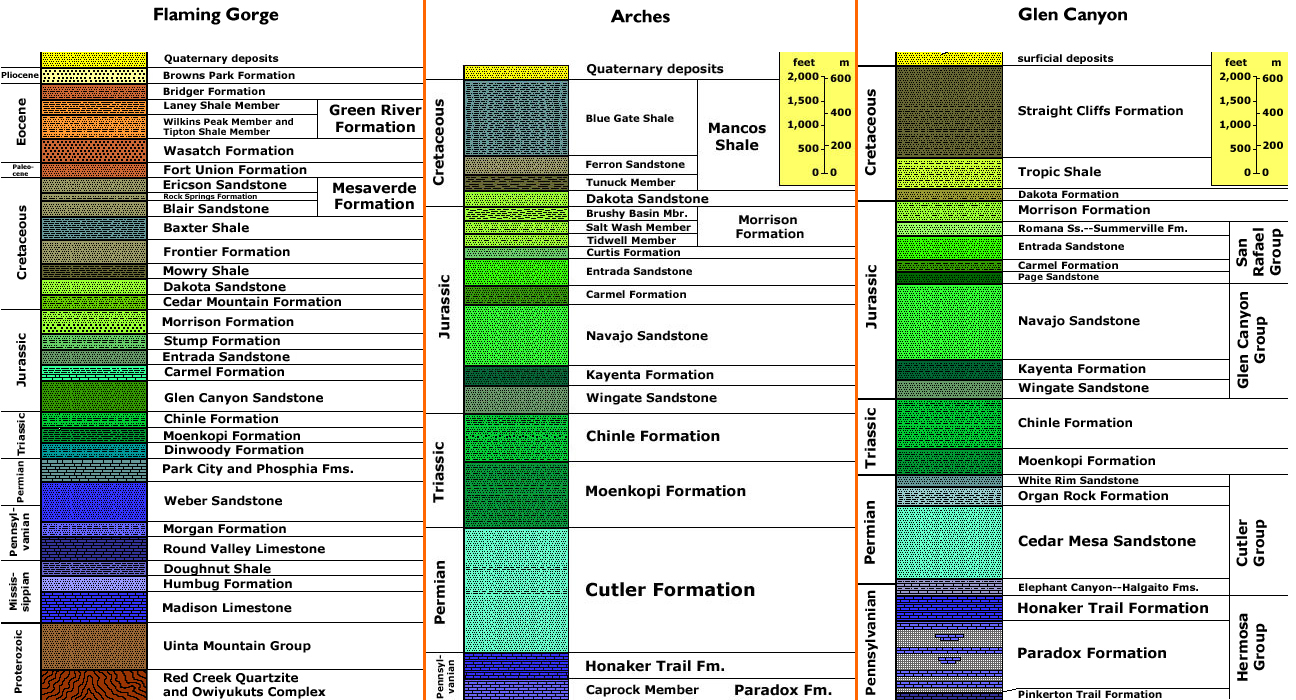 Comparing the three rock profiles.
- Place the visible rock profiles in order of age starting with the oldest. Explain the reasoning for your order. Flaming Gorge has the oldest visible rock. This is because the visible rock profiles from Arches and Glen Canyon stop at the Pennsylvanian Period, while Flaming Gorge rock continues on through the Mississippian and Proterozoic Periods. The second oldest is Glen Canyon, with Arches coming right behind it. The Glen Canyon formation is slightly older than the Arches formation because although Arches stops at the Paradox Formation, Glen Canyon shows one further layer, the Pinkerton Trail Formation, below the Paradox Formation.
- Examine the three rock profiles carefully.
- Which two rock profiles have the greatest similarity? Arches and Glen Canyon have the greatest similarity.
- Why would they be the most similar? They are closest to one another in distance.
- Was your prediction in question 2 correct? (Answers will vary depending on the original prediction.)
- What is the first rock layer that can be correlated across all three data sets? The Dakota Sandstone layer by the Cretaceous-Jurassic boundary is the first rock layer common to all three data sets. (Note: This layer is called the Dakota Formation in the Glen Canyon profile. This might have confused you and you might not realize that it is the same layer as the Dakota Sandstone layer in the other two profiles. If that is the case, then the Morrison Formation would be next layer common to all three profiles.)
- What are at least two other rock layers that can be correlated across all three data sets? Also include the geologic period within which these rock layers are found.
- Morrison Formation (Jurassic Period)
- Entrada Sandstone (Jurassic Period)
- Carmel Formation (Jurassic Period)
- Chinle Formation (Triassic Period)
- Moenkopi Formation (Triassic Period)
- Locate the Morrison Formation on the Arches and Glen Canyon diagrams (at the Jurassic-Cretaceous boundary).
- Use the scale in the diagrams to calculate the depth (in meters) of the Morrison Formation in Arches National Park and in the Glen Canyon National Recreation Area. The Morrison Formation is approximately 280 meters deep in Arches National Park, and approximately 147 meters deep in the Glen Canyon Recreation Area.
- Speculate on why this formation would have two different depths in the two areas. The most obvious reason is that there was probably a difference in sedimentation rates in the two different areas when the rocks in the Morrison Formation were being formed.
- Locate at least two rock formations that are common to Arches and Glen Canyon, but that are not found in Flaming Gorge. Also include the geologic period within which these rock layers are found.
- Navajo Sandstone (Jurassic Period)
- Kayenta Formation (Jurassic Period)
- Wingate Sandstone (Jurassic Period)
- Cutler Formation / Group (Permian Period)
- Honaker Trail Formation (Pennsylvanian Period)
- Paradox Formation (Pennsylvanian Period)
Possible answers could include:
Possible answers could include: