Although the most obvious feature of a volcano is clearly its cone, there are also many other interesting volcanic landforms. These include calderas, volcanic necks, dikes, sills, laccoliths, batholiths, and basalt columns.
A caldera is a large depression at the top of a volcano whose diameter exceeds one kilometer (0.6 miles). A caldera is formed as a result of a large explosion which destroys the upper part of the volcano, or when the magma chamber below a volcano is emptied. This loss of support from the magma chamber causes the summit of the cone to collapse usually resulting in a steep-walled, basin-shaped depression. The La Cumbre Volcano caldera is located on Fernadina Island, one of the chain of islands in the Galapagos Islands.
 This 1.5-km-wide (approximately 1-mile-wide) caldera on Mt. Katmai in Alaska was formed during a 60 hour long eruption that began on June 6, 1912.
A volcanic neck (or volcanic plug) is formed as an extinct volcano gradually erodes over time, wearing away the softer outer parts and leaving behind the much harder solidified magma in the central vent. This solidified central vent is the volcanic neck. One of the most spectacular examples of a volcanic neck in North America is the 550 meter (1,800 foot) high landform known as Shiprock that rises above the desert in New Mexico.
 Sigiriya is a volcanic neck situated in Sri Lanka. Sigiriya, also known as Lion’s Rock, is also an ancient fortress and rock ruin that is a UNESCO World Heritage Site.
Basalt columns are structures that form as a result of magma slowly cooling. The contraction and fracturing of the rock as the magma slowly cools results in conspicuous 5 to 7 sided columns. Basalt columns can be seen in many parts of the world, but the most famous example of basalt columns is known as the Giant’s Causeway, the most popular tourist attraction in Northern Ireland.
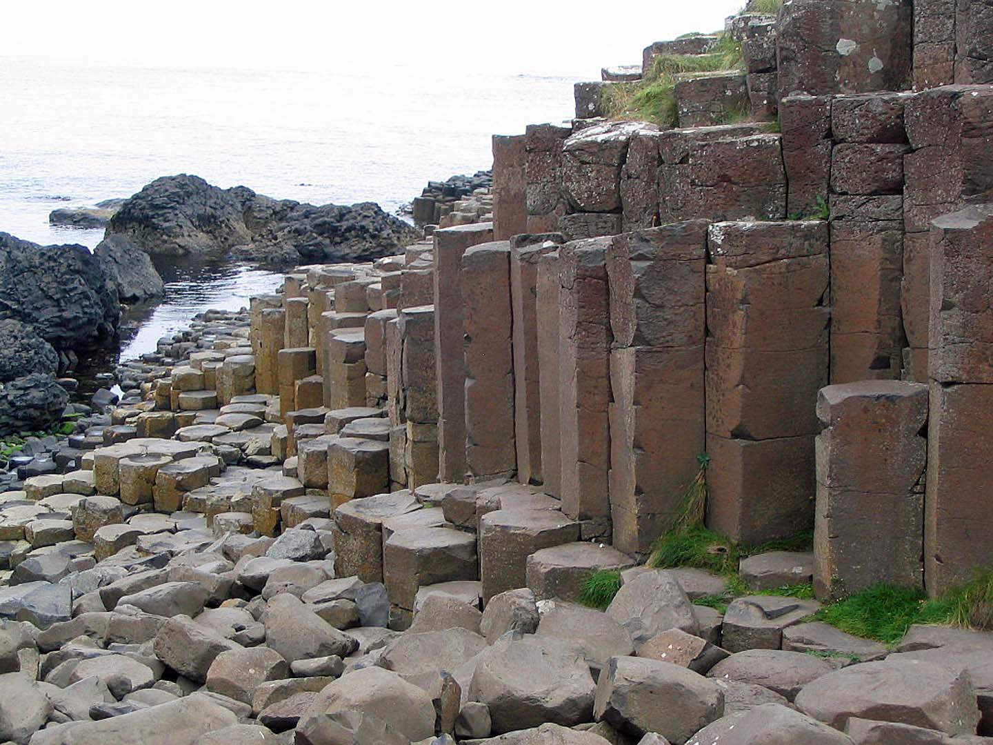 The fractured shapes of basalt columns are clearly visible at the Giant’s Causeway in Northern Ireland.
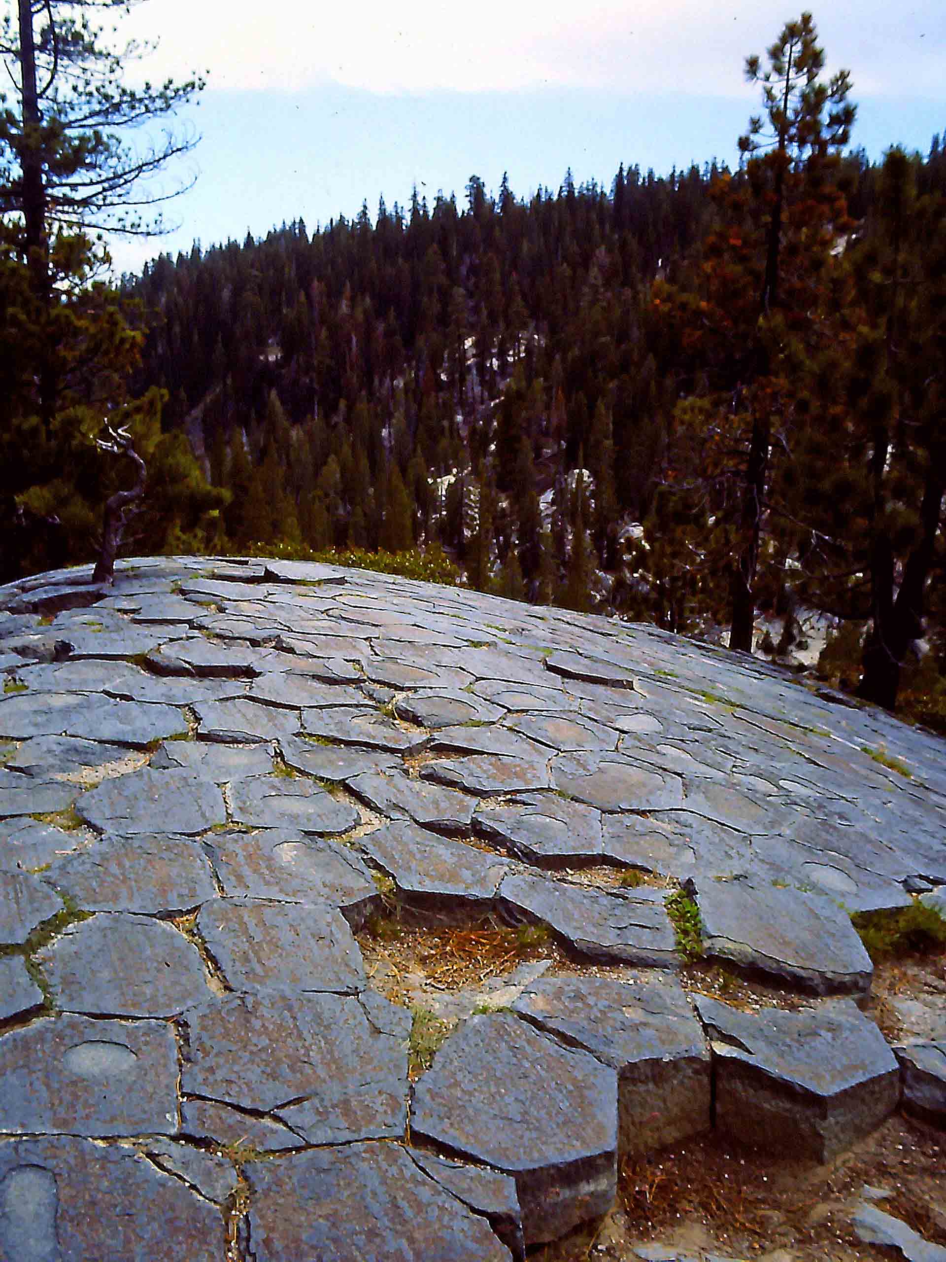 The polygon structure of basalt columns is clearly visible at Devil’s Postpile National Monument in California.
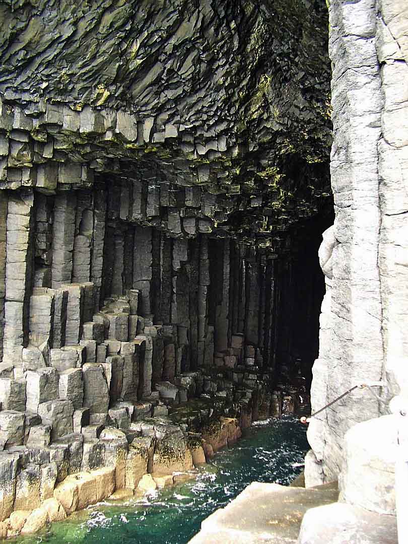
The basalt columns of Fingal’s Cave proved to be a musical inspiration for Mendelssohn.
Refer to the diagram below to help identfy the next set of volcanic features.
 A labeled diagram illustrating the location of dikes, sills, laccoliths, and batholiths.
A dike (labeled A in the diagram) is formed when magma enters a vertical or near-vertical fissure. A dike can range in thickness from one centimeter (roughly 0.5 inch) up to a kilometer (0.6 miles) or more. Most dikes, however, have an average thickness of only a few meters (roughly 10 feet). Since dikes are made of solidified magma, they are usually much harder than the surrounding rock. Erosion will eventually wear away this surrounding rock and leave behind the dike which appears as a thin vertical wall of rock.
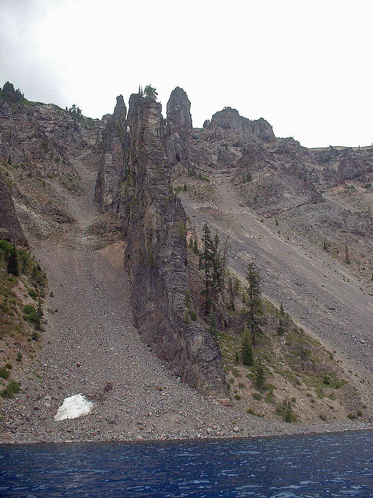 This dike at Crater Lake National Park in Oregon illustrates the typical “stone wall” appearance of these structures.
A sill (labeled B in the diagram) is very similar to a dike except that in the case of a sill, magma flows horizontally between layers of rock.
A laccolith (labeled C in the diagram) is formed when a small chamber close to the surface fills with magma which causes a rounded bulge in the overlaying rock layers.
A batholith (labeled D in the diagram) forms when a large mass of magma solidifies; it is basically a solidified magma chamber. A formation must have a surface exposure of at least 100 square kilometers (38 square miles) in order for it to be considered a batholith. The rock face known as Half Dome in Yosemite National Park in California is probably the single most recognized batholith structure in the world.
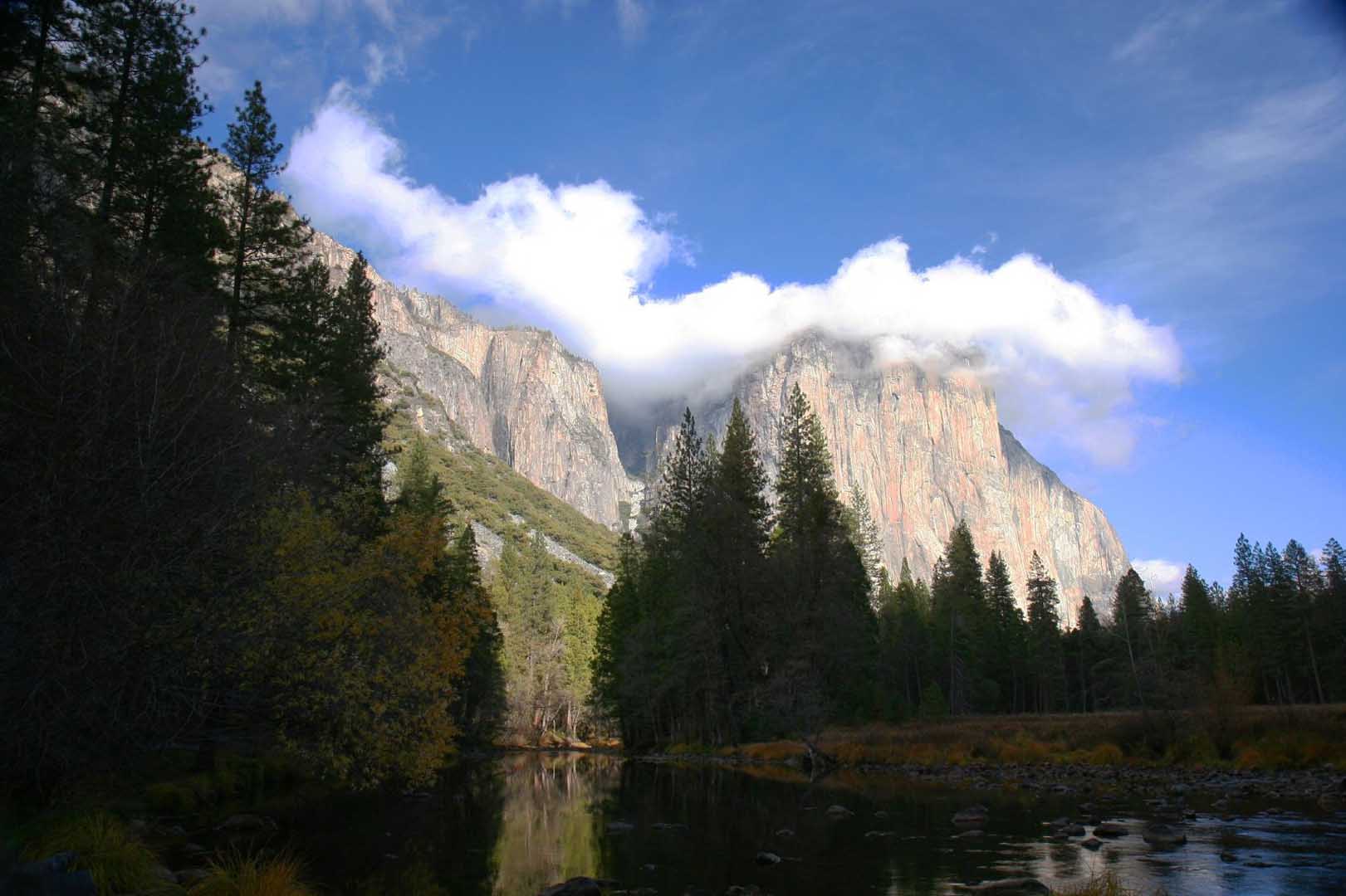 The famous rock-climbing wall known as El Capitan in Yosemite National Park in California is part of the Sierra Nevada batholith.
Exploring Crater Lakes
The presence of a nearly circular lake is often evidence of a major geologic event in the past. These lakes are known as crater lakes when they form inside a volcanic crater or caldera. These lakes are formed when precipitation slowly fills the depression caused by these volcanic events. (Crater lakes can also form inside the impact craters of meteorite strikes.)
The table below lists a series of almost perfectly circular crater lakes formed by catastrophic volcanic events.
- Click on each name in order to visit the site.
- Complete the table by using the circle tool to provide your best estimate of the radius of each crater lake. Then calculate the diameter by using your measured radius.
| Name | Location | Measured Radius (km) | Calculated Diameter (km) | Features |
| Lake Bracciano | Italy | 4.2 | 8.4 | caldera; drinking water reservoir for Rome |
| Lake Tazawa | Japan | 3.0 | 6.0 | caldera; deepest lake in Japan (423 m / 1,410 ft) |
| Kal'tsevoe Lake | Russia | 3.5 | 7.0 | caldera (Tao-Rusyr Caldera); lake is 400 m / 1,300 ft above sea level |
| Coatepeque Lake | El Salvador | 2.9 | 5.8 | 5.8 caldera; nominee for new 7 wonders of the world (nature category) |
| Crater Lake | Oregon, USA | 4.7 | 9.4 | caldera; deepest lake in US (594 m / 1950 ft) |
- What geologic feature is common among all the crater lakes in our activity?
All of the crater lakes in our activity occupy volcanic calderas. - Based on your measurements which crater lake represents:
- the largest caldera? Crater Lake in Oregon represents the largest caldera.
- the smallest caldera? Coatepeque Lake in El Salvador represents the smallest caldera.