Erosion and Niagara Falls
Objective: The purpose of this activity is to analyze the rate of erosion at Niagara Falls. Erosion rates in the past, present, and predicted future will be examined.
Materials Required: Everything that you need for this exercise is included in the on-screen components.
Time Required: approximately 45 minutes
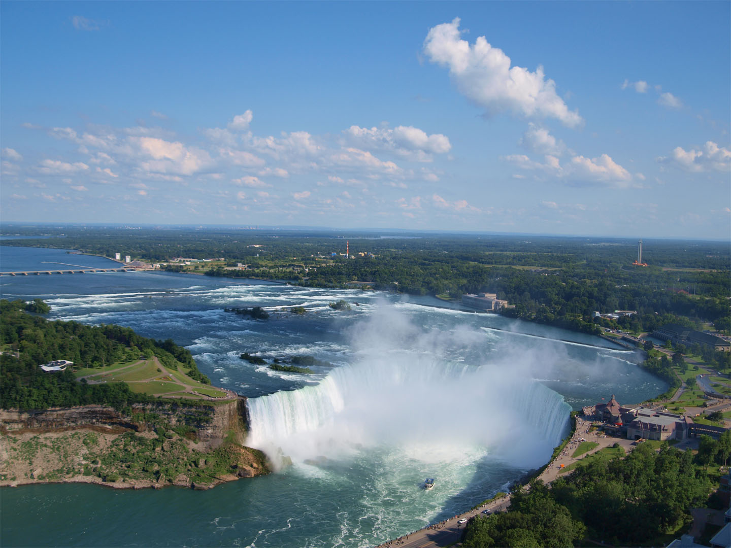 This part of Niagara Falls, the Canadian Horseshoe Falls, has a height of 57 meters (approximately 175 feet).
Niagara Falls is the most famous waterfall in the world. It is not the highest waterfall in the world; that honor falls to Angel Falls in Venezuela with a height of 979 m (approximately 3,200 feet and 18 times as high as Niagara). It is, however, the world’s greatest waterfall by volume with approximately 2,800 m3 (6 million cubic feet) of water going over the falls every second during peak daytime tourist hours. It is the combination of flow volume, height, and characteristic shape that makes Niagara Falls such a beautiful waterfall.
Niagara Falls is formed by the Niagara River falling over a large ridge known as the Niagara Escarpment as it flows from Lake Erie to Lake Ontario. People who have not actually been to Niagara Falls are sometimes surprised to discover that Niagara Falls really consists of three separate waterfalls. The American Falls and the much smaller Bridal Veil Falls lie on the American side of the border, while the largest waterfall, the Horseshoe Falls, lies predominantly on the Canadian side of the border. The water flowing over the Horseshoe Falls has been the dominant agent of erosion in the formation of the Niagara River Gorge. For the purposes of this exercise, whenever the term “Niagara Falls” is used, it refers to the primary erosion caused by the current Horseshoe Falls.
Niagara Falls traces its origin to when the Niagara area first became free of ice after the last ice age.
- Click here to see the extent of ice cover in the Niagara area 14,000 years ago.
- Click here to see the extent of ice cover in the Niagara area 12,000 years ago.
- When did the area between Lake Erie and Lake Ontario (i.e., the Niagara area) first become free of ice? The Niagara area became free of ice sometime between 14,000 and 12,000 years ago. (Current estimates by geologists place the Niagara area as being ice-free approximately 12,500 years ago.)
Geologists have determined that Niagara Falls originated 12,500 years ago as meltwater from the retreating glacier began to carve what is today known as the Niagara Gorge. The falls began on the north side of the Niagara Escarpment near the present-day settlements of Queenston (Canadian side) and Lewiston (American side).
- Click here to see where Niagara Falls began.
By 10,500 years ago, Niagara Falls had eroded to the location of the present-day Niagara Glen.
- Click here to see location of Niagara Falls 10,500 years ago.
Use the distance tool to measure the distance that Niagara Falls traveled upstream from its origins 12,500 years ago until it reached Niagara Glen 10,500 years ago.
- What distance did Niagara Falls erode from its point of origin (just above Queenston - Lewiston) to its arrival at Niagara Glen 10,500 years ago? Niagara Falls eroded a distance of approximately 4.5 kilometers from its origin to Niagara Glen. (Note: Answers will vary depending on how carefully this distance is measured. Because of the curving nature of the river path, measuring each relatively straight section individually and adding up all of the sections will give the most accurate answer.)
- What was the average rate of erosion for Niagara Falls (in meters / year) as it traveled from its origin to its location at Niagara Glen? Hint: Average rate of erosion = average speed of falls = (total distance covered) / (total time taken)) Average rate of erosion
= average speed of falls
= (total distance covered) / (total time taken)
= (4,500 meters) / (2,000 years)
≈ 2.3 meters / year
Changing drainage patterns resulted in Niagara Falls being stalled at Niagara Glen for approximately 5,000 years. About 5,500 years ago, Niagara Falls again began to advance as drainage flow returned to its previous pattern. Niagara Falls has continued to advance to this day. Accurate records about the location of Niagara Falls have been kept for the last several hundred years.
- Click here to see recent locations of Niagara Falls.
- Use the measuring tool to measure the distance eroded during each time interval. Use this measurement and the time interval to complete the following chart.
- Based on your answers in question 4, was the erosion rate constant? Can you think of any reasons to account for your answer? The erosion rate was not constant. The rate of erosion in the last 100 years has been greatly reduced. This may be as a result of flow control and the diversion of water for hydroelectric power stations. The falls, however, will continue to erode until they have worked their way all the way up the Niagara River to Lake Erie.
| Time Interval | Distance Eroded (meters) | Erosion rate (meters / year) |
| 1678–1764 | 0.10 | 100 meters / 86 years ≈ 1.2 meters / year |
| 1764–1819 | 0.05 | 50 meters / 55 years ≈ 0.91 meters / year |
| 1819–1842 | 0.08 | 80 meters / 23 years ≈ 3.5 meters / year |
| 1842–1886 | 0.04 | 40 meters / 44 years ≈ 0.91 meters / year |
| 1886–2005 | 0.05 | 50 meters / 119 years ≈ 0.42 meters / year |
(Note: Actual answers may vary slightly because of accuracy in measurements, and location of the measurements. Answers should, however, be similar to those above and in the correct relative proportion to one another.)
- Click here to see the Niagara River between the current location of Niagara Falls and Lake Erie.
Use the distance tool to measure the shortest distance along the Niagara River from the current location of the falls to the mouth of the river.
- What distance do the falls still have to erode before they reach the mouth of the Niagara River? The shortest distance between the current location of Niagara Falls and the mouth of the Niagara River is approximately 27.8 kilometers. (Note: The actual measured distance may vary depending on exactly how carefully the measurements are taken, and also on where the exact distance measurements are taken. The final answer, however, should be close to 27.8 kilometers.)
- Scientists calculate that at the current rate of erosion, Niagara Falls will arrive at Lake Erie in approximately 50,000 years. Use this information and your distance measurement to determine the current average erosion rate of Niagara Falls (in meters / year). Average rate of erosion
= (total distance covered) / (total time taken)
= (27,800 meters) / (50,000 years)
≈ 0.56 meters / year