Exploring the Ocean Floor
Objective: The purpose of this activity is to analyze in detail the topography of a small part of the Pacific Ocean. You will also examine how this part of the ocean floor is interacting with the surrounding area.
Materials Required: Everything that you need for this exercise is included in the on-screen components.
Time Required: approximately 45 minutes
Much of the ocean floor remained unfamiliar until marine exploration began in earnest some time after the end of the World War II. It was primarily the results of these oceanographic studies that finally convinced most scientists of the reality of continental drift. Much of this initial work was done in the Atlantic Ocean.
In this activity, you will examine a part of the Pacific Ocean that has also been widely studied. This area lies off the northern part of the U.S. Pacific coast, and extends to the coastal area of southern British Columbia. This is an interesting area because it exhibits many of the characteristics that led scientists in their earlier studies to validate continental drift. In this activity, you will analyze this area making use of the knowledge that you have gained in this unit on plate tectonics.
- Click here to view the area that you will examine.
- Click here for a better view of the topography of the ocean floor in this area.
- Describe the shape of the most prominent features visible on the ocean floor. There are a series of linear features on the ocean floor; some are in a zigzag pattern. A long depression is also visible.
- What do these features represent? They probably represent a chain of submarine mountains. The depressions in these chains are probably long valleys.
There are a number of fault lines clearly visible. Mentally locate them, and count the total number.
- How many fault areas are visible on the screen? There are four fault areas visible on the screen.
- Click here to view the the fault areas labeled.
- Click here for a better view of the actual fault lines drawn in.
- Click here to add in paleomagnetism data about this region. Pink-red colors represent normal magnetic pole orientation (i.e., the way it is today), while blue-purple colors represent reversed magnetic pole orientation.
- Which fault areas appear to have symmetric magnetic striping? Fault 1 and Fault 3 seem to have symmetric magnetic striping.
- What kind of fault must be present in these areas to account for symmetric magnetic striping? There must be a divergent fault in both of these areas.
- Click here to zoom in on the region surrounding Fault 1.
- Click here to see the positions of 5 magnetic stripes highlighted to the west of Fault 1.
Examine the screen and mentally locate each corresponding stripe to the east of Fault 1.
- Click here to check your answer.
- Click here to return to the overall view of the four fault lines.
- What kind of fault lines must Fault 2 and Fault 4 represent? Explain. Fault 2 and Fault 4 must be transform faults. These areas must be zones of relative sideways motion since Fault 1 and Fault 3 are divergent faults with oceanic crust moving apart at the fault zone.
- There is one more fault zone in this area. Click here to add in Fault 5.
- There is a mountain range just inland from Fault 5. Click here to see this mountain range.
- What is the name of this mountain range? This range is called the Cascades.
- This mountain range is made of a chain of volcanoes that stretch along the western coast and into Canada. Based on this information, what kind of fault would you then predict Fault 5 to be? Explain. Fault 5 is probably a convergent fault. It represents a subduction zone which is responsible for the creation of the chain of volcanoes known as the Cascade Mountains.
- Click here to see the subduction zone. The fault types are also clearly color coded.
All these faults together help outline a tectonic plate known as the Juan de Fuca Plate.
- Click here to see the Juan de Fuca Plate.
The Cascade Range was formed as a result of the Juan de Fuca Plate subducting under the North American Plate.
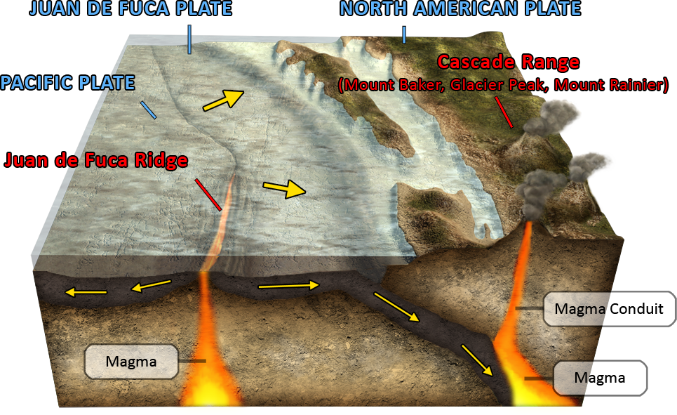 The boundary between the Juan de Fuca Plate and the North American Plate is a convergent fault zone.